LuxeVib UAV Aerial Survey Mapping Target: High-quality Aerial Survey Target


Available Options
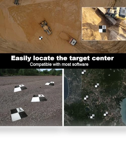
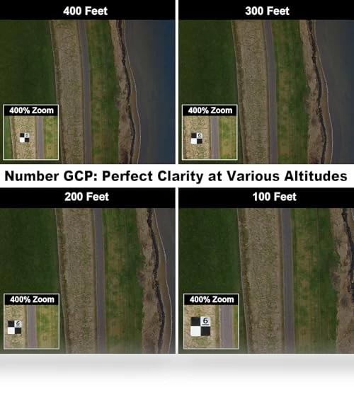
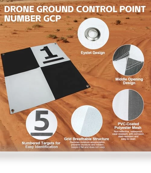
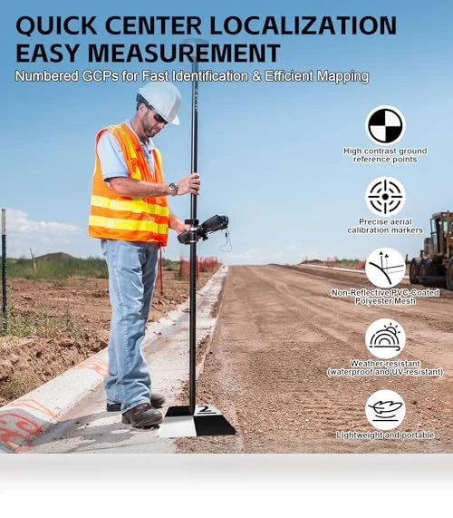
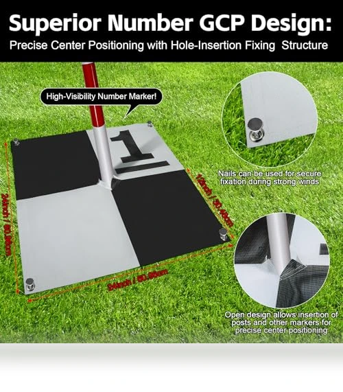
Ever tried getting your drone to play nice with maps? The UAV Aerial Survey Mapping Target is your new best friend. At 24" x 24", it's the Goldilocks size—not too big, not too small—just right for altitudes up to 400 feet. It's like the Swiss Army knife for drone mapping and photogrammetry, giving you a solid reference to scale and verify those maps. And with a center eyelet and corner anchor points, it's not going anywhere, no matter if it's windy, rainy, or you're on the side of a hill.
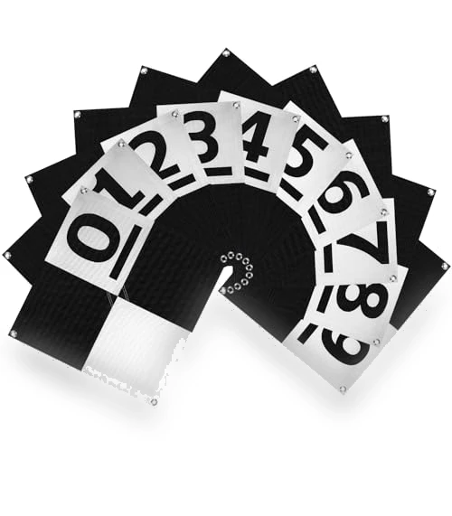
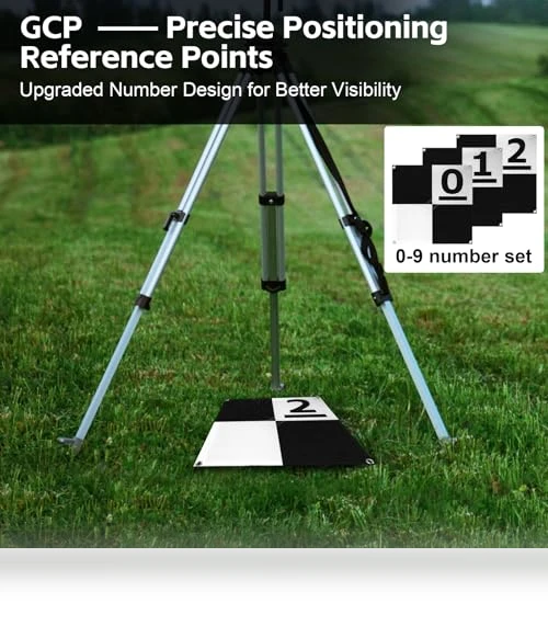
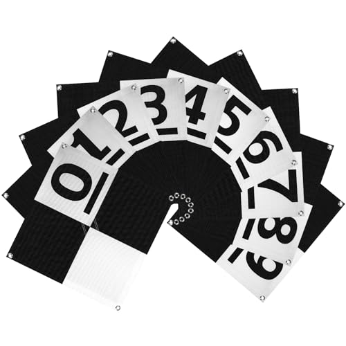
Made from non-reflective PVC and tough polyester mesh, these targets laugh in the face of water, UV rays, and just about anything else you throw at them. The matte finish? That's to keep the sun from photobombing your shots. Plus, with a checkerboard pattern and numbered markers (0-9), your photogrammetry software will recognize them faster than you can say 'data alignment'.
Lightweight, foldable, and easy to carry—because let's face it, nobody wants to lug around heavy gear. The center hole is a genius touch for precision measurements, and the corner holes make sure it stays put. Perfect for those long-term projects where you need high-precision, repeatable data. Because in surveying and mapping, accuracy isn't just nice to have—it's everything.
- Hole Design GCP
- Efficient Surveying Number GCP
- Affordable Number Set Ground Control Point
- Premium Fabric for GCP
- High-quality Aerial Survey Target
General specs
- Brand: LuxeVib
- Seller: Amazon
- package_dimensions: 15.52 x 13.59 x 2.56 inches
- weight: 2.27 Pounds
- date_first_available: April 4, 2025
- country_of_origin: China
- material: PVC coating reinforced by polyester mesh
- size: 24"x24"
- compatibility: Surveying Equipment, Drone Mapping
- First listed by seller: 6/7/25
If you are interested in more details, you can find full information on the seller's page.
 Buy on Amazon
#publicidad
Buy on Amazon
#publicidad
Shipping options
 United States
Video Reviews
Comparison with similar products
| This item | Recommendations | |||||
|---|---|---|---|---|---|---|

UAV Aerial Survey Mapping Target High-quality Aerial Survey Target
|

Autel EVO II PRO RTK V3 Real-time centimeter-level positioning
|

QAONIE K19 Advanced Aerial Delivery system
|

High-definition Aerial Photography Quadcopter High-definition aerial photography
|

Professional Waterproof RC Drone 4K Camera
|

Dual Camera Drone Dual camera setup
|
|
| Brand | LuxeVib | Autel | QAONIE | |||
| Model | EVO II PRO RTK V3 | K19 | E88 | 2023 | ||
| Color | ||||||
| Rating |
|
|
|
|
|
|
| Price | $85.99 | $3,299.00 | $139.99 | $59.99 | $59.99 | $74.99 |
| Seller | Amazon | Amazon | Amazon | Gshopper | Gshopper | Gshopper |
| Update | June 27, 2025 | June 27, 2025 | June 27, 2025 | July 25, 2024 | July 25, 2024 | July 25, 2024 |
UAV Aerial Survey Mapping Target
Megan Y.
Atlanta, GA
June 17, 2025
As someone who uses this for mapping work, I had to ask myself: does it really improve accuracy? The answer is yes, it seems very reliable for scaling and reference. I've used it a few times now, and it holds up well outdoors. It's not perfect—I've noticed it can be a bit tricky to set up perfectly flat on uneven ground—but overall, it's a solid tool. For the cost, I expected a bit more, but it does the job without any major issues. Delivery was fine, everything arrived as described.
- Pros: The size is perfect for my needs—not too large to carry around, but big enough to be seen from high up. It stays put even in windy conditions, thanks to the anchor points, and the material handles weather well without fading or getting damaged. I appreciate how lightweight and foldable it is, making it easy to transport for my projects. The pattern and markers help my software recognize it quickly, which speeds up my work.
- Cons: While it's generally durable, I wish it were a bit more rigid to avoid any slight bending in strong winds. The price point might be a bit high for those on a tight budget, and it could benefit from more color options for better visibility in certain environments. Packaging was intact, but nothing special—just functional.